Westminster tube station
Entrance within Portcullis House |
|
 Westminster
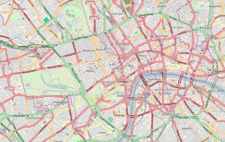
Location of Westminster in Central London |
|
| Location | Westminster |
|---|---|
| Local authority | City of Westminster |
| Managed by | London Underground |
| Platforms in use | 4 |
| Accessible | |
| Fare zone | 1 |
|
|
|
| London Underground annual entry and exit | |
| 2007 | 18.363 million[2] |
| 2008 | 19.05 million[2] |
| 2009 | 19.08 million[2] |
|
|
|
| 1868 | Opened (MDR) |
| 1872 | Started "Outer Circle" (NLR) |
| 1872 | Started "Middle Circle" (H&CR/MDR) |
| 1900 | Ended "Middle Circle" |
| 1908 | Ended "Outer Circle" |
| 1949 | Started (Circle line) |
| 1999 | Opened (Jubilee line) |
|
|
|
| List of stations | Underground · National Rail |
Westminster is a London Underground station in the City of Westminster. It is served by the Circle, District and Jubilee lines. On the Circle and District lines, the station is between St. James's Park and Embankment and, on the Jubilee line it is between Green Park and Waterloo. It is in Travelcard Zone 1. The station is located at the corner of Bridge Street and Victoria Embankment and is close to the Houses of Parliament, Westminster Abbey, Parliament Square, Whitehall and Westminster Bridge. Also close by are Downing Street, the Cenotaph, Westminster Millennium Pier, the Treasury, the Foreign and Commonwealth Office and the Supreme Court.
The station is in two parts: sub-surface platforms opened in 1868 by the Metropolitan District Railway (MDR) as part of the company's first section of the Inner Circle route and deep level platforms opened in 1999 as part of the Jubilee line extension from Green Park to Stratford. A variety of underground and mainline services have operated over the sub-surface tracks, but the original station was completely rebuilt in conjunction with the construction of the deep level platforms and Portcullis House which sits above the station.
Contents |
History
Sub-surface station


near Westminster station, 1866
The station was opened as Westminster Bridge on 24 December 1868 by the Metropolitan District Railway (MDR) (now the District line) when the railway opened the first section of its line from South Kensington.[3] It was originally the eastern terminus of the MDR and the station cutting ended at a concrete wall buffered by timber sleepers.[4] The approach to the station from the west runs in cut and cover tunnel under the roadway of Broad Sanctuary and diagonally under Parliament Square. In Broad Sanctuary the tunnel is close to Westminster Abbey and St Margaret's church and care was required to avoid undermining their foundations when excavating in the poor ground found there.[5]
The original station building was a temporary structure positioned over the tracks and the platforms were sheltered with individual awnings rather than the all-over glazed roof provided at the MDR's other stations. Access to the station was via a passageway from Bridge Street and a pedestrian subway under the road.[4] On 30 May 1870, the railway was extended to Blackfriars.[3]
The MDR connected to the Metropolitan Railway (MR, later the Metropolitan line) at South Kensington and, although the two companies were rivals, each company operated its trains over the other's tracks in a joint service known as the Inner Circle. On 1 February 1872, the MDR opened a northbound branch from its station at Earl's Court to connect to the West London Extension Joint Railway (WLEJR, now the West London Line) at Addison Road (now Kensington (Olympia)).[3] From that date the Outer Circle service began running over the MDR's tracks. The service was run by the North London Railway (NLR) from its terminus at Broad Street (now demolished) in the City of London via the North London Line to Willesden Junction, then the West London Line to Addison Road and the MDR to Mansion House – at that time the eastern terminus of the MDR.[6]

From 1 August 1872, the Middle Circle service also began operations through South Kensington, running from Moorgate along the MR's tracks on the north side of the Inner Circle to Paddington, then over the Hammersmith & City Railway (H&CR) track to Latimer Road, then, via a now demolished link, on the WLEJR to Addison Road and the MDR to Mansion House. The service was operated jointly by the H&CR and the MDR.[6] On 30 June 1900, the Middle Circle service was shortened to terminate at Earl's Court,[7] and, on 31 December 1908, the Outer Circle service was withdrawn from the MDR tracks.[8] In 1907, the station was given its present name.[3]
By the mid 1890s the station entrance had been incorporated into a larger building.[9] In 1923 a new ticket hall and side entrance from Victoria Embankment were designed by Charles Holden.[10] This is believed to be the architect's first project for the London Electric Railway (the main forerunner of London Transport and Transport for London).[11] The station platforms were also refurbished with new wall tiling in the green, blue, black and white tiling scheme used later by Holden on many stations of the period and still visible at neighbouring St James's Park station. In 1949, the Metropolitan line-operated Inner Circle route was given its own identity on the tube map as the Circle line.[3]
Between late 1962 and early 1964 the east ends of the platforms were extended to allow longer 8-car trains to be operated. This involved carefully enlarging the tunnels under the Metropolitan Police's original headquarters at New Scotland Yard (now Norman Shaw Buildings).[12] The station was completely rebuilt to incorporate new deep-level platforms for the Jubilee line when it was extended to the London Docklands in the 1990s. During the works, the level of the sub-surface platforms was lowered to enable ground level access to Portcullis House.[13] This was achieved in small increments carried out when the line was closed at night.
Deep-level station

When the first section of the Jubilee line was planned in the 1970s, the second phase of the project was intended to continue the line eastwards from the terminus at Charing Cross to the City of London, Woolwich and Thamesmead.[14] Westminster station would not have been on this planned route, but the need to provide transport infrastructure for the redevelopment of the London Docklands in east and south-east London led to a redirection of the route to run via Westminster to connect Waterloo and London Bridge stations with the new developments.[15] For the Jubilee Line Extension, the buildings around the station were demolished and the sub-surface station was completely reconstructed together with the building of a parliamentary office building, Portcullis House, which sits above the station. Both projects were designed by Michael Hopkins & Partners.[16][17]

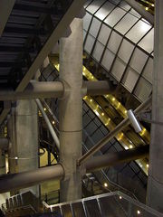
The construction of the deep-level station involved the excavation of a 39-metre (128 ft) deep void around and beneath the sub-surface station to house the escalators to the Jubilee line platforms. The void, known as the station box, was the deepest ever excavation in central London and was carried-out between thick reinforced concrete diaphragm walls stiffened and braced horizontally for stability. Under Bridge Street, on the south side of the station box the two Jubilee line platform tunnels are arranged vertically with the westbound platform below the eastbound. The depth of the station box excavation and the proximity of the tunnels represented a significant risk to the stability of the foundation of the Houses of Parliament's clock tower, only 34 metres (112 ft) from the edge of the station box. To protect the foundation and manage settlement in the sub-soil, a series of 50-metre (160 ft) long steel tubes was installed horizontally around and beneath the clock tower's 3-metre (9.8 ft) thick foundation. The tubes were provided with a control system through which grout was injected into the ground to compensate for settlement detected from detailed measurements of the clock tower's position. As excavation of the station box and the tunnels took place, grout was injected on 22 occasions between January 1996 and September 1997. The process limited the movement of the clock tower to an acceptable maximum of 35 millimetres (1.4 in). Without the grout injection, the movement would have been at least 120 millimetres (4.7 in) causing cracking to the structure of the tower and the Houses of Parliament.[13] The Jubilee line platforms were opened on 22 December 1999, although trains had been running thorough the station without stopping since 20 November 1999.[3]
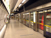
The station's architecture is an austere combination of concrete and stainless steel, with stacked banks of escalators supported from the cross bracing structures spanning the station box and routes for passengers entering or leaving the station separated from those changing between lines.[18] As with the other underground stations on the extension, the Jubilee line platforms feature platform screen doors to improve airflow through the system and increase safety. The station design won a number of awards including Civic Trust awards in 2000 and 2002, the Royal Fine Art Commission Millennium Building of the Year award in 2000 and the RIBA Award for Architecture in 2001.[19] Both projects were jointly short-listed in 2001 for the RIBA's prestigious Stirling Prize.[20]
Services
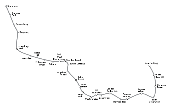
The station is in London fare zone 1. On the District and Circle lines, the station is between St James's Park and Embankment, and, on the Jubilee line, it is between Green Park and Waterloo. Train frequencies vary throughout the day, but generally District line trains operate every 2–6 minutes from approximately 05:25 to 00:38 eastbound and 05:49 to 00:37 westbound; they are supplemented by Circle line trains every 8–12 minutes from approximately 05:49 to 00:24 clockwise and 05:36 to 00:19 anticlockwise. Jubilee line trains operate every 2–5 minutes from approximately 05:28 to 00:48 eastbound and 05:38 to 00:31 northbound. [21]
Transport links
London bus routes 3, 11, 12, 24, 53, 87, 88, 148, 159, 211, 453 and night bus routes N2, N3, N11, N44, N52, N87, N136, N155, N159 and N381 serve the station.[22][23]
Notes
- ↑ "Step free Tube Guide". Transport for London. December 2009. http://www.tfl.gov.uk/assets/downloads/step-free-tube-guide-map.pdf. Retrieved 8 February 2010.
- ↑ 2.0 2.1 2.2 "Customer metrics: entries and exits". London Underground performance update. Transport for London. 2003-2009. http://www.tfl.gov.uk/tfl/corporate/modesoftransport/tube/performance/default.asp?onload=entryexit. Retrieved 22 May 2010.
- ↑ 3.0 3.1 3.2 3.3 3.4 3.5 Rose 1999.
- ↑ 4.0 4.1 Horne 2006, p. 9.
- ↑ Walford 1878, pp. 224–242.
- ↑ 6.0 6.1 Horne 2006, p. 15.
- ↑ Horne 2006, p. 30.
- ↑ Horne 2006, p. 44.
- ↑ Maps of the period show it thus – For example, 1896 OS map.
- ↑ Day & Reed 2008, p. 96.
- ↑ "Photograph details, Image no: U22453". London Transport Museum. Transport for London. http://www.ltmcollection.org/photos/photo/photo.html?_IXSR_=gYinNVHLvjF&_IXMAXHITS_=1&IXinv=1998/51356&IXsummary=results/results&IXsearch=westminster%20station&_IXFIRST_=17. Retrieved 28 February 2010.
- ↑ Horne 2006, p. 90.
- ↑ 13.0 13.1 Mair & Harris 2001, pp. 23–27.
- ↑ Day & Reed 2008, p. 183.
- ↑ Day & Reed 2008, p. 201.
- ↑ "Westminster Underground Station". Hopkins Architect. http://www.hopkins.co.uk/projects/_8,109/. Retrieved 4 June 2010.
- ↑ "Portcullis House". Hopkins Architect. http://www.hopkins.co.uk/projects/_5,100/. Retrieved 4 June 2010.
- ↑ Day & Reed 2008, p. 213.
- ↑ "Awards". Hopkins Architect. http://www.hopkins.co.uk/information/awards/?&sort=38&skip=136. Retrieved 10 June 2010.
- ↑ Taylor, David (13 September 2001). "Stirling Prize 2001: seven to fight it out". The Architects' Journal. http://www.architectsjournal.co.uk/home/stirling-prize-2001-seven-to-fight-it-out/183995.article. Retrieved 9 June 2010.
- ↑ "Timetables". Transport for London. http://journeyplanner.tfl.gov.uk/user/XSLT_SEL_STT_REQUEST?sessionID=0&language=en&mode=line&linePreSel=tfl:25:*&linePreSel=tfl:63:*&linePreSel=nrc:90:*&withoutTrains=0. Retrieved 11 June 2010.
- ↑ "Buses from Westminster". Transport for London. http://www.tfl.gov.uk/tfl/gettingaround/maps/buses/pdf/westminster-2298.pdf. Retrieved 11 June 2010.
- ↑ "Night buses from Westminster". Transport for London. http://origin.tfl.gov.uk/tfl/gettingaround/maps/buses/pdf/westminsternightbuses-11497.pdf. Retrieved 11 June 2010.
References
- Day, John R; Reed, John (2008) [1963]. The Story of London's Underground. Capital Transport. ISBN 1-85414-316-7.
- Horne, Mike (2006). The District Line. Capital Transport. ISBN 1-85414-292-5.
- Mair, Robert; Harris, David (August 2001). "Innovative engineering to control Big Ben's tilt". Igenia (Royal Academy of Engineering) (9). http://www.ingenia.org.uk/ingenia/issues/issue9/Mair.pdf. Retrieved 11 June 2010.
- Rose, Douglas (1999) [1980]. The London Underground, A Diagrammatic History. Douglas Rose/Capital Transport. ISBN 1-85414-219-4.
- Walford, Edward (1878). "Underground London: Its railways, subways and sewers". Old and New London. vol. 5. http://www.british-history.ac.uk/report.aspx?compid=45233. Retrieved 31 May 2010.
- Wolmar, Christian (2005) [2004]. The Subterranean Railway: How the London Underground Was Built and How It Changed the City Forever. Atlantic Books. ISBN 1-84354-023-1.
External links
- London Transport Museum Photographic Archive
- Westminster station photo gallery
- More photographs of Westminster station
| Preceding station | London Underground | Following station | ||
|---|---|---|---|---|
|
towards Hammersmith
|
Circle line |
St. James's Park
towards Edgware Road
|
||
|
St. James's Park
towards Wimbledon, Richmond or
Ealing Broadway |
District line |
towards Upminster
|
||
|
Green Park
towards Stanmore
|
Jubilee line |
Waterloo
towards Stratford
|
|
||||||||||||||||||||||||||||||
|
|||||||||||||||||||||||||||||||||||
|
|||||||||||||||||||||||||


